The Snowiest Winter Ever – by Ham Mehlman
October 11, 2025
Posted in
Ham Mehlman is Editor-in-Chief of Mountain Passages and an AMC-NH member. He skis, hikes and bikes New Hampshire’s backcountry, trails and byways when time allows.

Some folks, maybe more than a few, seem convinced that every New Hampshire winter of yore had horse drawn sleighs sliding along paths banked with clean, white snow piled high. “Yore” being defined on a sliding scale based on age: the younger generation might be talking about 25 years ago; the graybeards may be thinking 50. In our minds, winters of yore, every one of them, had sleighs and piles of very white snow that never turned gray. And we preface our recollection with “I remember when…,” of course implying that we were there. Call it “our Currier and Ives memory”. Never mind that New Hampshire has always had its lean snow years. Our minds ignore or purge any images of the inevitable January thaws, dreary cold rains, dirt sullied snowbanks, muddy and patchy ski slopes. Recalling pristine, serene beauty is far more inspiring and pleasant, even if a little disconnected from reality.
Our recollections and memories are fuzzy compilations of favorite images and wishful visions of perfection. How memory works, and the widely acknowledged issue of “memory distortion”, is actually a long standing field of serious study that has fascinated the likes of shrinks and neuroscientists since at least when Freud started noodling on the issue. “In essence, all memory is false to some degree. Memory is inherently a reconstructive process, whereby we piece together the past to form a coherent narrative that becomes our autobiography.”
So what is the narrative for our Currier and Ives recollection of winters past? Currier and Ives published their scenes in the late nineteenth century. Unless you are sipping some fountain-of-youth elixir, these memories derive from art that Currier and Ives, and other landscape artists of that period, recorded in lithographs, oils, watercolors and other media. They are interpretations of landscapes with all the exaggerations and personal perceptions that come with “artistic license.” And these memories are static and romanticized. They recall a moment in time, perhaps those magical hours in the wake of a fresh snowfall. They delete the intervening reality from the historical record.
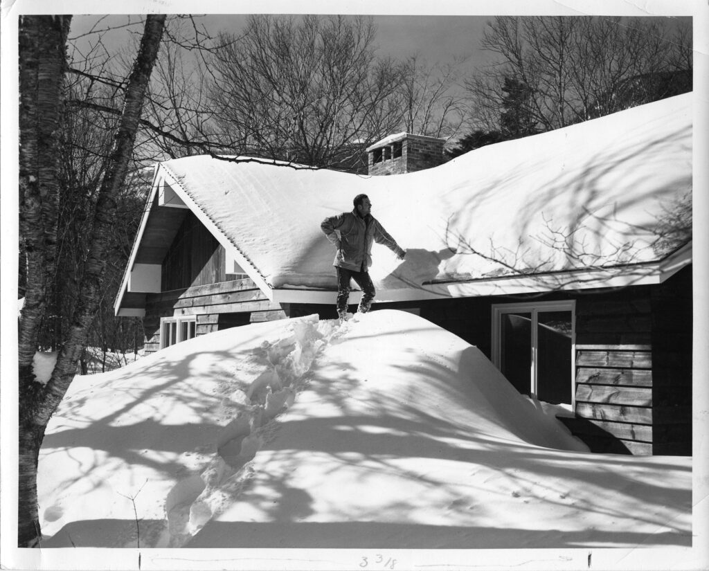
If you are over 55, however, maybe your Currier and Ives memory derives from a real experience, the winter of 1968-1969. It was a winter that really validated the image of the horse drawn sleigh sliding over a snow covered path with enormous snowbanks, all season long. It would prove to be the snowiest New Hampshire winter on record. The Mt. Washington Observatory recorded 566.4 inches (47 feet) of snow, still a seasonal record and more than double the summit’s average annual snowfall. At one point, Pinkham Notch measured its snowpack at 164 inches – more than 11 feet. This remains the deepest snowpack on record for an inhabited area of New England. And snow was everywhere. Vermont reported snow depths up to 149″ in the valleys and fields and Stowe carried a ski base of greater than 200 inches through much of February and March, this in the days well before snow making…. Up to 84″ covered the fields and forest of much of Maine. Even in Boston, we piled snow high along the streets.
On Mt. Washington, our measure of all things weather, snow started falling in earnest in November 1968. The Observatory measured 87″ of snow, ice and hail, still a record for that month. One nameless storm dumped 25″ in a single day, still the record for 24 hours in November. Snow kept pounding the peak through December, 104″, the highest recorded snowfall for December and included a day with 38″ another standing record. The snow machine paused a bit in January, spewing 57″, above average but unremarkable in the history of Januarys on Mt. Washington. Snow through February 21st doubled the monthly average of 40″, helped by 10-30 inches from a powerful Nor’easter on February 8-10, a pwerful “bomb cyclone” with a 32 millibar drop in its central pressure over 18 hours. 341″ had fallen so far year to date. Skiers reveled and it looked like a long spring for Tuckerman enthusiasts.
Then we made weather history.

Snowfall by Month (inches) on Mt. Washington Summit during the 1968-1969 Winter Season Compared to Average

Record Monthly Snowfall – Hiughlighted Entries are From the 1968-’69 Season
During the week of February 22, per Tim Dennis of the New England Storm Center reporting in 1969, a strong nor’easter worked its way up the Atlantic coast. Weather forecasting in February 1969 was limited compared to current standards, with forecasts relying on manual analysis of weather charts and basic models lacking the sophisticated real-time data analysis, satellite imagery and predictive models used today. Forecasters called the storm but not the magnitude. The low stalled in the Gulf of Maine for days pumping moisture (snow) across all of New England, particularly Maine, New Hampshire and Eastern Massachusetts, with its counterclockwise rotation. Mt. Washington and the White Mountains trapped this moisture and wrung out the system as it scaled the mountains.
Today, meteorogists would classify the 100-hour storm of 1969 as a “Miller B type Bomb Cyclone”, a description not used in 1969. “A classic Miller B storm involves a primary low-pressure system moving eastward across the central U.S. (often from Alberta), weakening as it crosses the Appalachians, and a secondary low then developing and strengthening rapidly off the East Coast. This secondary development near the coast often leads to significant coastal storms.” Once off the East Coast, the central pressure dropped dramatically, a hallmark of “bombogenesis” or a “bomb cyclone.”
Even so, the storm was unusual and a bit in a class by itself according to a recent talk by Mt. Washington Observatory (MWOBS) Weather Observer and Education Specialist, Alexandra Branton, who described the 1969 100-hour storm as “reminiscent of a coastal cyclogenesis storm (bomb cyclone) BUT, unusual due to messy dynamics and lack of thermal contrast at the surface. She also noted that nor’easters don’t typically drop huge precipitation in the White Mountains although significant storms. Yet this storm did.
For four days straight, periods of moderate to heavy snow fell across much of New England in what became known as the “100-Hour Storm”.


Over the course of the blizzard, Mt. Washington received just under 100 inches of snow, or around eight feet, which stands, as by far, the most snow in New England from a single storm. 49.3″ of this snow fell on the summit on February 25th. This still stands as the most snow to fall in 24 hours in New England’s history. February 1969 would go on to be the summit’s snowiest month ever, with its instruments recording 173 inches (14 feet) falling from February 1-28.
Without doubt, at least for one winter, 1968-‘69 justified Currier and Ives depictions of New England winters. It was a real life corroboration of all those artistic scenes to experience and remember. The days after the 100-Hour Storm were the Currier and Ives moments for the generation old enough to live through the experience with images to confabulate in their minds of how things used to be.
But the scale of the “100-Hour Storm” was not imaginary. There have been plenty of big storms, but only the largest and most distinctive earn a name. And the 100-Hour-Storm earned its stature as the biggest and baddest for the amount of snow it shed across a really substantial area.
NOAA actually calculates a statistic called the “Regional Snow Index” (“RSI) to rank the impact and magnitude of snowstorms. As with hurricanes and tornadoes, RSI uses a scale of 0-5 with 5 being the most severe. Out of over 500 snowstorms assessed since 1900, only 26 have earned a 5 rating. Yup, the 100-Hour-Storm is one of them, number four in the rankings by score and tops in the Northeast. Scientists at NOAA and Rutgers developed the RSI to assess storm impact and magnitude. It factors in the area of snowfall accumulation, the amount of snowfall and the population in the affected areas, scaling this information by region. For example, it factors in that people in New Hampshire can manage 30″ of snow way better than folks in Atlanta can navigate 2″.
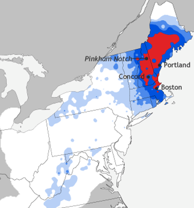
Area Impacted by 100 Hour Snow Storm in February, 1969. Red Indicates More Than 30 Inches of Snow.

At number four on the all-time list, the 100-Hour Storm was a certainly a massive event with more than 2 million people over 16,000 square miles digging out from 30″ or more snow. By comparison, the March 1993 “Storm of the Century”, number 2 on the RSI scale for the Northeast region, buried only 725,000 people with 30 plus inches. And the “Great Blizzard of 1978” that so many from Boston refer to as the grandaddy of all storms only scores 18.42 compared to 34.69 for the 100-Hour Storm, although both rating a five on the RSI. Locally, the Goreham-Berlin area declared a disaster with more than 10 feet on the ground.
The one day total of 49.3″ on Mt. Washington is the record for the Northeast. For context, other locales, all in the west, have reported greater snowfalls. Most weather bureaus seem to recognize a 1921 dump of 75.8 inches on Siler Lake, CO as the 24 hour record in the continental states. But Silverlake sits at 10,220 ft in the Rockies and was a very localized event as are many of the big total storms in the West. Note New Hampshire’s total on the map.

March of 1969 would record another 24 hour record storm of 25″. Then the engine ran out of power and additional monthly snowfalls for the rest of the 1968-’69 snow year, including March, would track a bit below normal. Cumulatively though, the Mt. Washington Observatory recorded 566″ during the 1968-69 snow year, the most ever, at least in the Northeast. But lest we be too impressed, the Mt. Baker Ski Area reported 1,140 inches (95 feet) at elevation 4,200 ft. during the 1998-99 winter season. Around here, Jay Peak seems to be in its own little pocket, even reporting 475″ this past ski season (2024-’25).
And it didn’t just snow up high. The winter of 1968-’69 buried Pinkham Notch where the AMC had a front row seat to Nature’s fury. One of remarkable aspects of the history of AMC is the records and notes it has kept over the years.
Bruce Sloat, the AMC Huts Manager in 1969, filed the following report about Pinkham Notch in Appalachia:
“All in all it was quite a winter. The total snowfall for the year was an impressive figure – 317 inches in Pinkham Notch.
” It was a battle to keep the parking lot open and the roofs from caving in. Snow depth on the back of the Robson building became so great that a snowblower had to be purchase and carried up on the roof. All first floor windows were completely covered. On the staff residence where I live the snow got up as the mid-point of the second story windows.
” The ski touring trails which were marked early in the season with markers placed as high as a man could reach has to be remarked twice during the winter. The markers on the trees now average 15-17 feet in the air. Tour skiing was superb and a trail wasn’t really ncessary as all underbrush was covered and pinned down by the heavy snow.”
No memories required here…
For the annual right-of-passage in Tuckerman’s Ravine, 1969 was “epic” with skiing well into July. Peter Allen recently posted a picture of Tuck’s from June 19, 1969 on the “Friends of Tuckerman Ravine” Facebook page still showing deep coverage of even the headwall. Per the Littleton Courier “Tuckerman Ravine filled up with 80 ft. compared to the normal 50 ft.” and it was still March.
Memories have their own existence whatever they are based on. Undoubtedly, the romance and style of the Currier and Ives image is the reality of every winter for some of a distant past. And some remember their own version of history perhaps from a parent or grandparent.
Paul Dougherty wrote a column for the Littleton Courier in 1969 called the “Northwoodsman”. In his reporting on the storm, he seems to weigh personal recollections on par with data, noting, “The winter of 1968-‘69 will go into the history books, as far as snowfall is concerned… The weather records for the past nearly 100 years also prove this.” But as if not quite trusting the science, he uses personal recollection to corroborate the claim, “Even my neighbor, Bill Nickerson, says he never saw so much snow on the ground on Gorham Hill in his 50 years there…” He also manages to dig up plenty of “you should have seen…” recollections to put the 100-Hour Storm in its place. Dougherty writes: “One can get some interesting reactions about this being quite a winter, however. One man I spoke to about it said, ‘Yes it’s quite a winter alright, but you should have been around in 1919.’ Another quote I got was, ‘Doesn’t compare to 1918.’ Still another person said, ‘the winter of ’26 was the real one.’ I didn’t ask if he meant 1826. No doubt he did.
“The prize quote came from Jasper Hogan of Gorham,” Dougherty continues. “Jasper is an old woodsman, a man of the outdoors all his life. He stopped me the other day and said, ‘You know, another big storm like that last one and this will be like an old-fashioned winter.’ With a grin on his face he turned and walked away.”
And then there is Dougherty’s reference to “old timers” who, in 1969, seem to vividly recall the “Great Blizzard of 1888″ despite it snowing a mere 24 inches.
And, of course, your perspective probably influences your recollection as much as anything. If you were in 6thgrade in 1968, you might remember the winter a bit differently. For Shelly Adams Whitmore, writing in a 2022 Facebook chat, the memory of 1968-‘69 was, “I believe that was the year we had the whole month of February off from school. Cancelled due to snow, extreme cold and February vacation week.” Yippee – what you remember is all about perspective.
1968-1969 – the snowiest winter ever.

Tuckerman Ravine on June 19,1969 – Peter Allen
Further reading and references:
- The 100-hour now storm of February 1969, Mike Squires, Climate.gov
- A Winter to Remember: Comparing this Season to the Winter of ’68-’69, Taylor Regan, Mount Wahington Observatory
- Looking Back at new England’s Longest Snowstorm: The 100 Hour Storm, Tim Dennis, New England Storm Center
Please send recollections or comments to comments@amc-nh.org . Please indicate if we can publish!