A New White Mountain 4,000-Footer Challenge? The White Mountain “4k x 4k” List – by Ham Mehlman
May 24, 2025
Posted in
Ham Mehlman is Editor-in-Chief of Mountain Passages and an AMC-NH member. He skis, hikes and bikes New Hampshire’s backcountry, trails and byways when time allows.
“4,000 feet” is a hallowed height in the White Mountains. It’s a nice round height, a marketable number. Of course its roundness is a function of imperial units – “1,219.2 meters” doesn’t sell particularly well.
By any rational assessment, its status derives from a purely arbitrary decision: Nathanial Goodrich’s cutoff for the minimum height to use for his 1931 list of White Mountain summits to tag. Today, hikers recognize an updated version of Goodrich’s list as the White Mountain Four Thousand Footers List managed by the AMC Four Thousand Footer Club, one of the most successful and recognizable hiking challenges in all of mountaineering. As of January 1, 2025, 18,691 humans and 496 canines had formally earned their patches for completing the challenge, probably many thousands more without bothering to record their feat.
Intentional or not, the list owes part of its success to a bit of sophistry. Like all elevations, the White Mountain summits are measured relative to sea level – 4,000 feet above sea level. But no hiker of the Whites starts their summit quest at sea level (ignoring the Appalachian Trail [AT] hikers…). Popular trailheads in the region range in elevation from approximately 990 feet – e.g. the Davis Path – to 3,000 feet at the base of the Caps Ridge Trail. You simply cannot get much lower, even hiking longer distances. The elevation of Gorham is 794 ft.; Jackson, 758 ft.; Franconia, 928 ft.; Lincoln, 810 ft. etc. And popular trailheads such as those in Crawford Notch at 1,895 ft., Pinkham Notch at 2,028 ft., Lafayette Place at 1,800 ft., and Marshfield Station at 2,400 ft., start much higher. You get the picture. The White Mountains emerge from a plateau approximately 1,000 feet above sea level. Your 4,000 foot summit is most often not a 4,000 foot climb. In fact, it is less than 4,000 net vertical feet for 41 of the 48 peaks on the White Mountain Four Thousand Footers list. When your buddy boasts about scaling a White Mountain 4,000 footer, chances are that they didn’t climb 4,000 feet or, more accurately, they didn’t gain 4,000 feet in net elevation as suggested by the list name.
So how about adding some integrity to a 4,000 footer list? Call out the sophistry. Anoint the real knarly dudes or dudesses. Formulate a 4,000 footer list that credits actually scaling 4,000 ft. of vertical relief (summit elevation minus lowest trail elevation), not just tagging summits – “peak-bagging” in the parlance.
Let’s call it the White Mountain 4k x 4k List (WM 4k x 4k): 4k for the minimum vertical relief climbed where vertical relief is simply the summit elevation minus the lowest trail elevation and 4k because 4,000 feet is a hallowed height and defines the theoretical minimum height for a peak to qualify.
THE WM 4k x 4k LIST CHALLENGE:
Scale the 20 distinct “aspects” (think sides) of White Mountain peaks with 4,000 feet of vertical relief and a one-way trail length less than ten miles. These ascents total approximately 87,600 feet of vertical relief (vertical relief is simply the summit elevation minus the lowest elevation of a trail, the trailhead in all cases here).
What is so relevant about vertical relief? Elevation gain or vertical relief was a concept that likely had no audience in 1931. Summit tagging was and still is the primary measure. You check the same box for summitting Mt. Washington whether you start from the trailhead for the Caps Ridge Trail gaining 3,200 feet over 5.3 miles or ascend 5,295 feet via the Davis Path over 15 miles. (This is not remotely to diminish the difficulty of the Caps Ridge Trail: it is a bear.) For some checkmarks, all that is required is to clamber up another 200’ of vertical along a ridge, if that is where the next peak is. But the effort expended (work) is all in the elevation gain. Ascending 2,000 more feet on the Davis Path or being required to climb each mountain separately is a lot more work than starting from the Caps Ridge Trailhead at elevation 3,008 feet or scoring multiple summits along a ridge without having to restart at the bases. Why? Work = Force x Distance, a formula I’m sure everybody fondly recalls from high school physics. In our simple model for work, gravity is the only relevant force, and gravity only pains us when there is a change in elevation. (I know, technically that implies that we don’t do any work walking 15 miles on a flat surface – BS! – but we will stick with the simple model here because the next model up involves a cosine.)
Perhaps such a list exists but none is evident from my google or ChatGPT queries. It’s not clear that any one dataset currently suffices to generate a list on its own. The White Mountain Guide (WMG) – and presumably its associated database – contains a lot of the relevant data but the mapping function of AllTrails and topographic data from the USGS are also needed, particularly with varying levels of public access and query capabilities. For example, the WMG and many other resources such as AllTrails, highlight “elevation gain.” Elevation gain is a very useful statistic for a hiker, totaling the amount of uphill work over the length of a trail – if the trail periodically descends for a bit, the metric factors in the added elevation rise to regain that height. This is different than the proposed criteria of “vertical relief” or net elevation gain, which simply subtracts the lowest elevation (usually the trailhead) from the summit elevation. There could be a lot of up and down in between trailhead and summit…. As a preliminary compilation for a WM 4k x 4k List, I used my human computer to connect data from these sources.
Using the same prominence criteria for the White Mountain Four Thousand Footers list, there are ten peaks to consider: the highest peaks measured by LIDAR subtracting 800 feet for the lowest relevant topographic elevations within ten miles of a summit. Not surprisingly, the biggest reliefs in the White Mountains are found on the tallest peaks and predominantly in the Northern Presidentials:

Of course, there are multiple approaches (“aspects”) to most of these summits starting at different trailheads and scaling different sides with different trail lengths. The path chosen on each “aspect,” from the perspective of vertical relief, is irrelevant as long as the length is less than ten miles according to our (arbitrary…) cutoff. The human computer identifies 20 relevant aspects totaling 87,600 vertical feet on seven qualifying peaks to include in a challenge.
Aspects sorted by mountain:

Aspects sorted by largest potential Vertical Relief:

Ascents range in length from 3.8 to 9.7 miles one way:

In summary, we find 20 “aspects” on seven peaks to include in the WM 4k 4k List. Five peaks are in the Presidential Range and two in the Franconia Range.
This is a preliminary analysis by a fallible human computer. Any additions, corrections or comments welcome at newsletternh@amc-nh.org .
Maps with potential trails for each aspect can be seen below:
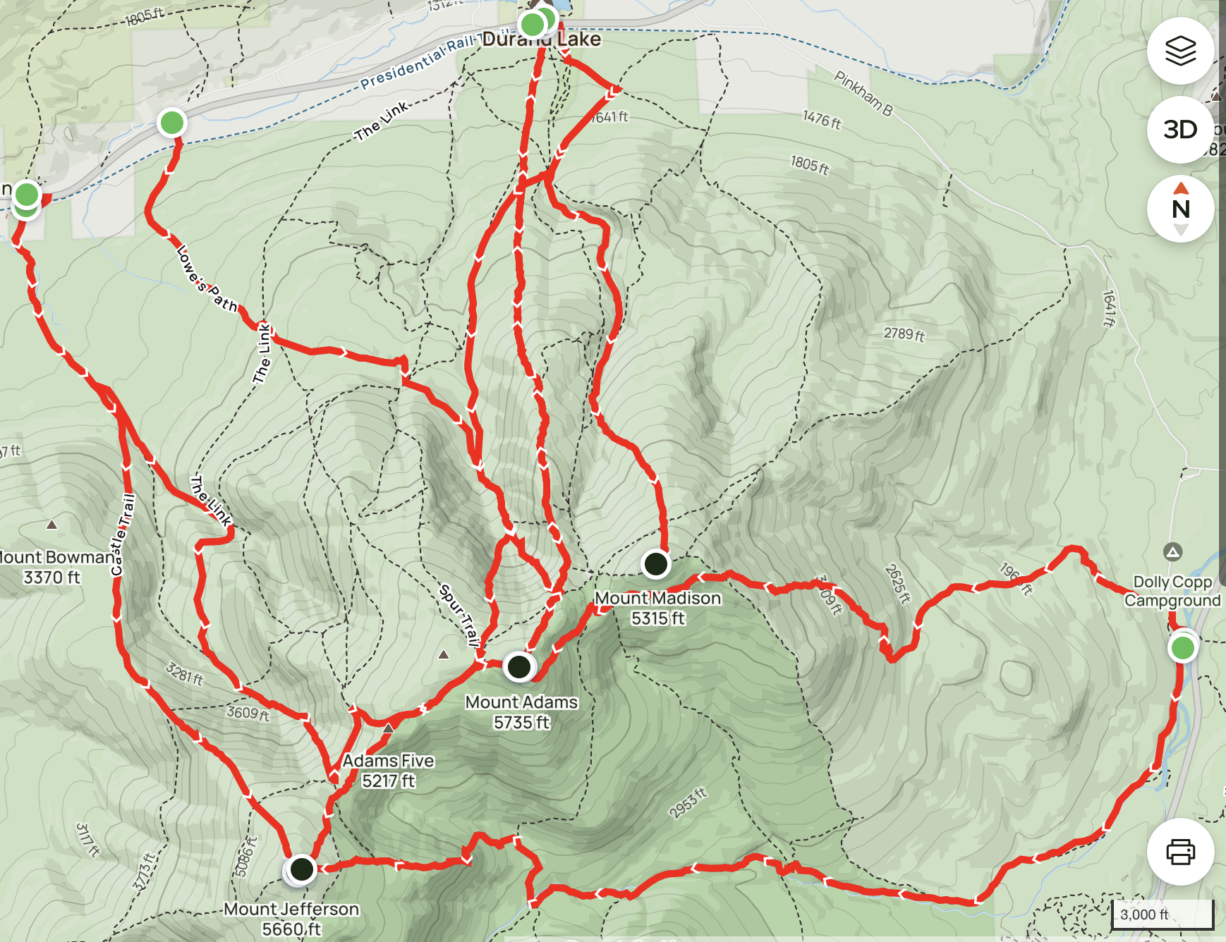
Aspects in Northern Presidentials:
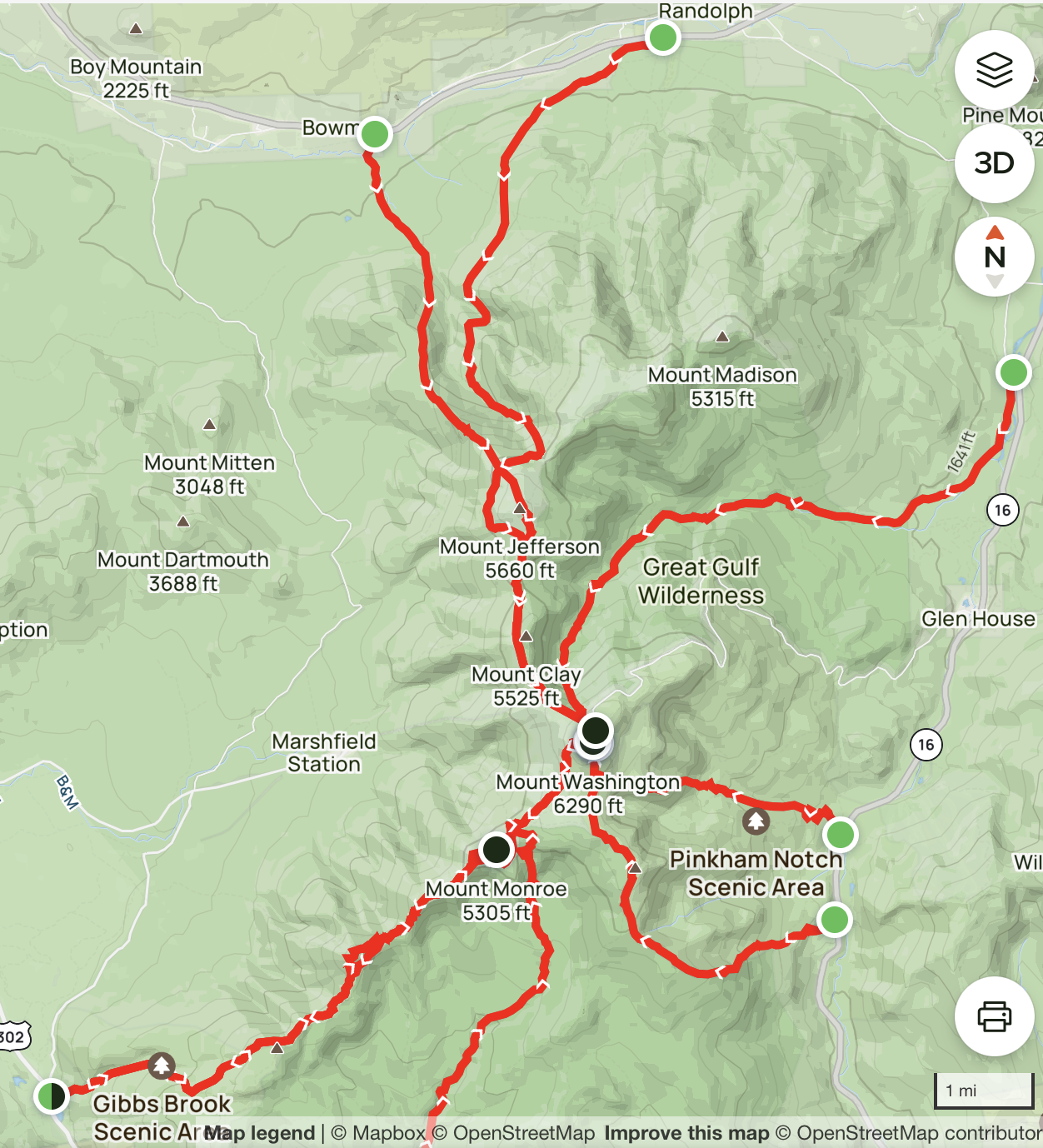
Washington and Munroe 4k x 4k Aspects
Franconia Range Aspects on Mt Lafayette and Mt Lincoln

Food for further thought:
- I’ve noted the potential for including Mt. Moosilauke in the challenge despite not quite meeting the 4,000 foot criteria
- I should think we could find a hole at the base to gain an additional nine feet
- Moosilauke adds a third range to the equation and a nice southern anchor to the project.
- Maybe Moosiluake will be the Tecumseh of the WM 4k x 4k List! (For those not following the connection, the USGS survey marker atop Mt. Tecumseh has read 3,997 feet since 2019 based on both LIDAR and GPS surveys, dropping it below the 4,000 foot threshold. By vote in 2021, the AMC Four Thousand Footers Club elected to continue to recognize Tecumseh and the heights of the 48 peaks based on their 1998 revision for historical reasons, “at least until new USGS quadrangle maps are published”. Surely the three-foot-plus-tall cairn on the summit of Tecumseh addresses the issue. Similarly, perhaps someone can locate a nine-foot hole to justify adding Moosilauke to the WM 4Kx4k List…)
- There is no formal “trailhead” at the Coal Hill Road intersection with Route 18, in Franconia. But, from here hikers can navigate to the Skookumchuck Brook Trail via Magowan Road, as well as logging and local trails. Alternatively, it is possible to achieve 4,000’ plus vertical relief starting at the Lawrence Forest or the Tuckerbrook trailheads, also at the base of Three Mile Hill. Except for a traverse at the base of the Cannon Mountain ski area, there are hiking trails connecting to the Greenleaf Trail to the summit of Lafayette from these trailheads. One aspect of note about the Coal Hill Road trailhead is that you can see the vertical relief to the summit of Lafayette from Rte. 18 near the trailhead – on a clear day, that is. There are views from Rte. 16 in the Northern Presidentials, where you get a sense of the scale of 4,000 vertical relief, but not from the trailheads themselves. This may be the only aspect where the whole relief is visible from the base.