Is Mount Washington the Biggest, Baddest Mountain in the East? – by Ham Mehlman
August 7, 2025
Posted in
Ham Mehlman is Editor-in-Chief of Mountain Passages and an AMC-NH member. He skis, hikes and bikes New Hampshire’s backcountry, trails and byways when time allows.
Around these parts Mt. Washington is number one – the biggest, baddest knob from our provincial perspective. We are aghast to hear that Mt. Washington (“Mt. W”) isn’t technically the loftiest peak in the Appalachian range or the East. No, Mt. Mitchell in North Carolina owns this distinction reaching 6,684 ft. in elevation. Ironically, Mt. Mitchell rises in the Black Mountains in the Central Blue Ridge Range. Our Mt. Washington of the White Mountains isn’t even the tallest along the famed Appalachian Trail (AT): that honor belongs to Kuwohi (formerly known as Clingman’s Dome) reaching 6,643 ft. In fact, a bunch of those mounds in the Smokies and Central Blue Ridge ranges show little respect for Mt. W. with 12 of them sneering down at him. Mt. W. is only the 13thhighest in the East on the list from Peakbagger.com at 6,286 ft.. (Peakbagger doesn’t even concede Mt. Washington’s longtime traditionally reported height of 6,288 ft deferring to recent LIDAR measurements which shrink him a couple of notches.)

Is it case closed, or can we admirers muster arguments in support of Mt. W. as the biggest and baddest in the East? We can and we will.
Our points start with the definition of a mountain:
Google AI assistant defines a mountain as “a natural elevation of the Earth’s surface, rising significantly higher than the surrounding land, with steep slopes and a distinct peak or summit. While there is no universally agreed-upon definition, several factors like elevation, prominence, and geological formation contribute to what we consider a mountain.”
Aha. Elevation is just one consideration in defining a mountain. An opening indeed. One of our expert witnesses defines elevation as, “a fundamental property of the Earth’s surface that measures the radial distance of a point on the surface above an equipotential surface known as the geoid.” That is the problem with expert witnesses… For the rest of us, elevation is defined as the height above mean sea level. But is sea level relevant to the “bigness” of most mountains? For most mountains, the seas are hundreds, even thousands of miles distant. The sea is irrelevant to our appreciation of these peaks. We expect mountains to tower over us, soar into the skies and, by definition, “rise significantly higher than the surrounding land.” Elevation tells us nothing about soaring; it is just a number. Lake Tahoe in the Sierras (6,226 ft.) and the town of Jackson Hole in WY (6,238 ft.) are beautiful spots. But they are the low spots in their landscapes (after all, water does flow downhill and, well, a hole is a hole). They are also almost exactly the same elevation as the top of Mt. W. Denver CO sits at a mile high, just 1,000 ft. less in elevation than Mt. W but it sits at the base of the Rockies, not the top. La Paz, a capital of Bolivia (Bolivia has two capitals) sprawls much higher above sea level at nearly 12,000 ft. but the only indication of its elevation is difficulty breathing when you get off the plane. And then there is the “roof of the world” – the Tibetan Plateau – where the average elevation is 14,800 ft. above sea level, 2.35 times the height of Mt. W. The Tibetan plateau, with its barren steppes spreading to all horizons, is about as far as it gets from our image of a mountain and you can fit about twelve New Englands in its 970,000 sq, mile expanse, every inch of it higher in elevation than Mt. W. So maybe elevation is a poor measure of size and bigness for a mountain. Geographyrealm.com distinguishes elevation from the term “altitude”, which most use interchangeably. Geographyrealm.com geographers define altitude as the “height of an object above the surface of the ground or sea level based on a datum, a geodetic reference point. Altitude is the vertical measurement of the distance of an object above the surface of the Earth.” So how do we assess the “altitude” of a mountain which some would refer to as “vertical rise”, and the mountaineering community formally refers to as “prominence”?
Writing on the topic of “Topographic Prominence” in 2017, Andrew Kirmse and Jonathan de Ferranti assert that elevation, isolation and prominence are all important objective measures for defining a mountain. But of the three they conclude that “in many ways prominence is a better measure of the ‘interestingness’ of a mountain than is elevation.”
They define “prominence” in three ways:
- “The minimum vertical distance one must descend from a peak in order to climb a higher peak.
- “The difference between the height of a peak and the water level that would make the peak the highest on an island
- “The difference between the height of a peak and the lowest contour line that encloses no higher peak.”
And if these definitions are a bit obtuse, this graphic from Wikipedia hopefully clarifies the difference between elevation and prominence:

Vertical arrows show the topographic prominences of three peaks on an island. For the lefthand peak its prominence is the same as its elevation since the base is at sea level. For the two peaks on the right the base of their prominences is the highest contour connecting the mountain to is parent peak (the dashed lines) sometimes defined as the “key col”. Curved arrows point from a peak to its parent.
While Wikipedia credits Stephen Fry with first applying the term “Prominence” to the measured height from peak to highest col, the concept has been around since the 1930’s. Nathaniel Goodrich required 300 feet of topographic prominence for the 36 mountains included in his original AMC White Mountain 4000-Footers list in 1931.
Over the last 15 years or so brilliant software programmers have integrated advanced computing power, powerful mathematical algorithms and Digital Elevation Modeling (DEM) created with sophisticated mapping tools including LiDAR, Satellite imagery and aerial photography, to produce ever-more detailed databases of Topographical Prominences across the globe. Using a 300 ft. cutoff, Kirse and Ferranti compiled prominences for 1,634,026 peaks and published their results and methods in Progress in Physical Geography in 2017. In 2023, Kirmse updated his list using denser DEM data to identify an astonishing 2,027,005 peaks around the world with 300 feet of prominence. Much of their work and data can be found on the Peakbagger.comwebsite. Filtering this data, Peakbagger has curated many lists specific to various regions or ranges, including a list for the Appalachians. The source list for the data here is titled “Eastern USA 5,000 Peaks”.
Using the same 200 ft. prominence criteria AMC currently uses for compiling its “White Mountain 4,000 Footers” list, Kirmse and Ferranti ranked Mt. W. number one in prominence at 6,146 ft.; Mt. Mitchell will have “try harder”. It is number two (6,089 ft.). Perhaps using this data Mt. W. can lay claim to being the “biggest” peak in the East.

Ranking number one is not just a numerical sleight of hand here. As stated above, Kirmse and Ferranti assert that “in many ways prominence is a better measure of the ‘interestingness’ of a mountain than is elevation.” Per Wikipedia, “Prominence is interesting to many mountaineers because it is an objective measurement that is strongly correlated with the subjective significance of a summit. Peaks with low prominence are either subsidiary tops of some higher summit or relatively insignificant independent summits. Peaks with high prominence tend to be the highest points around and are likely to have extraordinary views.” And the folks at Peakbagger.com conclude that “many feel that prominence-based lists yield a more impressive line-up of summits than traditional elevation lists.”
Kirmse’s prominence data is ultimately rational and scientifically derived: after all he is a graduate of MIT. The analysis quantitatively supports the case for Mt. W. as much as elevation may support Mt. Mitchell. But prominences are still just numbers trying to describe a mass that can be empirically seen and experienced. And the numbers may not correspond to what is seen and experienced for reasons buried in the way they are derived. For all peaks the key determinant of prominence is the location of the “key col” used to determine the base elevation. Cols are the highest bridges connecting a mountain to its taller parent mountain. The number of potential cols decreases with gains in elevation as the number of potential parents shrinks. The consequence is that it can be a real road trip to the “key col” for the tallest peaks. Mt. W’s “key col” is the Champlain Canal, 127 miles away from the summit. For Mt. Mitchell the “key col” is the Chicago Ship and Sanitary Canal 520 miles distant! Unless you are Forest Gump you probably won’t be scaling the entire prominence of either just as your net vertical feet gained is always less than the stated elevation (unless you start on a beach). And for many other hikes, prominence dramatically understates the potential experience. Mt. Madison, for example, only has a prominence of only 466 ft., yet a hiker will be scaling more than 4,000 feet of vertical if they start from the Randolph side. So perhaps we need to assess the experience locally – what can you actually see and hike.
In 2019, Phillip Prince from the Virginia Tech Active Tectonics and Geomorphology Lab posted a provocative article titled, Searching for the “Biggest” Mountain in the Appalachians… and why is “Biggest” in Quotes. Prince wanted to know where he could find “the zone of biggest relief” and “where the most impressive Appalachian straight-line climbs could be found.” He arbitrarily drew circles with radii of 2.5 miles, 6 miles and 10 miles around candidate peaks (based on elevation) and calculated the difference between the lowest contours within the circles and the peak elevation. Mt. W topped its Southern competitors for elevation gained at 2.5 miles and was close or equal in height gained from six and ten miles out. Interestingly, Mt. Mitchell, despite being the tallest by elevation doesn’t make the list at any calculated distance. Prince concludes, “Mt. Mitchell is a bit further removed from low elevation valleys and thus is not quite as prominent over short or moderate distances.”

Mt. LeConte in Tennessee looks like a serious competitor and certainly offers a big experience over 6 or 10 miles but fails the prominence score with a tally of just 1,361 ft.
Comparing potential trails to experience on Mt. W. and Mt. Mitchell further supports the greater magnitude of the experience on Mt. Washington. If you squint the trails from Pinkham Notch are at the limit of Prince’s 2.5. mile radius and scale approximately 4,200 ft to the summit in 3.8 miles, a grade of 31%. In summary, at a comparable direct distance of 2.5 (+/-) miles, a hiker is climbing more vertical feet on a steeper slope than on Mt. Mitchell. The climb is simply tougher on Mt. W. (and can be really gnarly if you choose to ascend via Huntington’s ravine…). And there are six other aspects with vertical relief up to 5,300 ft. over varying distances on Mt. W. Mt. Mitchell has two long routes to evaluate. The vertical relief for both are similar around 3,600 ft. The Black Mountain Crest Trail is11.2 miles base to summit with an average grade of 6%; the Mt. Mitchell Trail is 5.7 miles one way with an average grade of 12%.


Hiking routes with at least 4,000 feet of elevation gain up different aspects of Mt. Washington. Most aspects have multiple routes to choose from.
Elevation heat maps from Topographic-map.com also support the greater presence, the “Bigness”, of Mt. Washington. Mt. Washinton is simply more isolated and singular compared to Mt. Mitchell which rise out of a broader elevated plateau. You see less of the height of Mt. Mitchell from virtually any aspect. Bottom line, in person Mt. Mitchell is not as impressive as our Mt. W., at least looking up at it.

Heat map of elevations of the area approximately 10 miles in radius around summit of Mt. Washington
Heat map of area approximately 10 miles in radius around summit of Mt. Mitchell

And if other metrics don’t statistically substantiate Mt. Washington’s preeminence as the biggest and baddest peak in the Appalachian Range then just compare weather reputations. Mount Mitchell does not have a weather observatory comparable to the Mount Washington Observatory but has recorded regular readings by various means since about 1925 with a few gaps in the record, most notably 1965-1980. Per these records, however sporadic, the all-time low temperature on Mt Mitchell is -34°F and the highest speed for a wind clocks in at 178 mph. In discussing the “extreme weather” on top of Mt. Mitchell a park attendant whined, “Christmas Eve of last year, 2022, was the most extreme conditions I have seen in my career. The temperature was -21°F, the wind was gusting between 50 and 60 mph, and the wind chill was roughly -70°F at the time I was up here that morning” – tropical by average winter conditions atop Mt. Washington. The Mount Washington Observatory (MWOBS) has, of course, continuously monitored weather in all seasons with sophisticated instruments since being founded in 1932. But the records contain reasonably continuous and detailed weather observations from the summit of Mt. Washington dating back to 1870 thanks to multiple facilities (e.g. the Summit House and Tip-Top House etc.) that have decorated the summit since the 1850’s. In a 1940 issue of Appalachia, Charles J. Brooks, then Director of the Blue Hill Observatory outside of Boston, first deemed Mt. Washington to have “the worst weather in the world”. In this article, he compared Mt. Washington’s weather to that of other extreme locations around the globe, according to the American Meteorological Society. In 1934, MWOBS measured a 231mph blast of air atop Washington, the world’s strongest recorded wind for the next 62 years. Mt. Washington averages 110 days per year with hurricane-force winds (74 mph or greater). Just in 2023 the hardy folks at the MWOBS reported a wind chill of -108°F, a new record in misery for the continental US by that standard. On the same date the air temperature dipped to -46.7°F, not quite as frigid as the -70°F (-56.7°C) recorded at Roger’s Pass in Montana in 1954 but pretty damn chilly and probably a record for the Appalachian range if such records were kept.
Mt. Washington has more recorded deaths on its terrain, 178 by some records, than any peak in North America, a sobering statistic that is not quoted lightly. Over the period of 1947-2022 Mt. Washington saw the same number of fatalities as Grand Teton in Wyoming and ranked only behind Denali/Mckinley, Rainier and Hood for most deaths on US peaks during the period. Mt. Washington makes every list of most perilous peaks in the world sharing this distinction with more obvious and larger mountains such as K2 and Mount Blanc. Mt. Washington’s capricious and extreme weather factored in many of these deaths. The records for Mt. Mitchell may be pretty fragmented but a very cursory investigation found only one death report for Mt. Mitchell, Elisha Mitchell in 1857. Certainly in this respect Mt. Washington has proven itself a far more perilous environment.
In 2013, Ryan Knapp, MWOBS weather Observer/Meteorologist posted the following comparison:
So, how’d our highest peak in the northeast (Mount Washington, NH – 6288ft) compare to the highest peak in the east (Mount Mitchell, NC – 6684ft)? Our peak is in the White Mountains; theirs is in the Black Mountains. Our peak is above tree line in an “alpine zone” with trees ceasing at about 4000 feet; their peak was generally covered in a dense spruce-fur forest. Our peak is covered in rocks; theirs had mostly dirt. Our peak is prominent standing shoulders above all neighboring peaks; their peak was surrounded by other 5000-6000 footers. It was still prominent but not to the extent ours appears to be (but I might be slightly bias). Our peak sees colder highs and lows, but that is more due to latitude and location and not so much on height. The same can be said for precipitation and snowfall. Our weather station is considered manual while theirs appears to be automated (from what I could tell). Our summit has the Mount Washington Auto Road that runs 7.6 miles from NH Route 16 to the summit (and the Cog on the opposite side) while theirs has a road that runs 4.6 miles from the Blue Ridge Parkway to the summit. Our views are awesome, extend for miles and miles and worth taking in; their views…well theirs are awesome, extend for miles and miles and just as worth taking in. So while our peaks may be different in many ways both are still able to leave their guests and employees with a sense of beauty and awe while imparting memories that will last a lifetime.
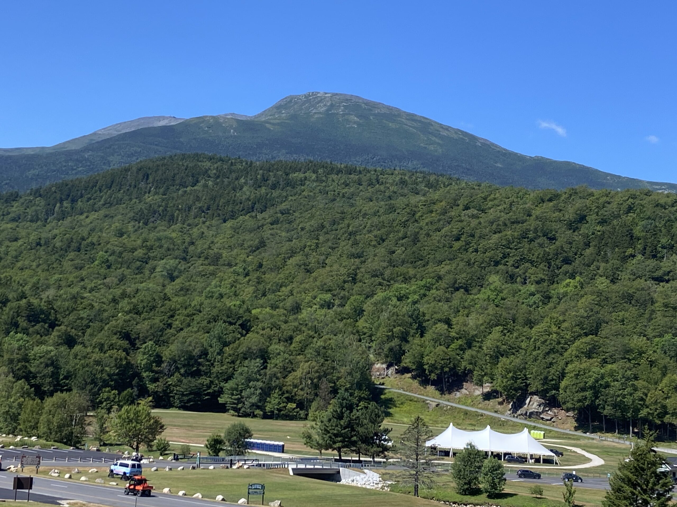
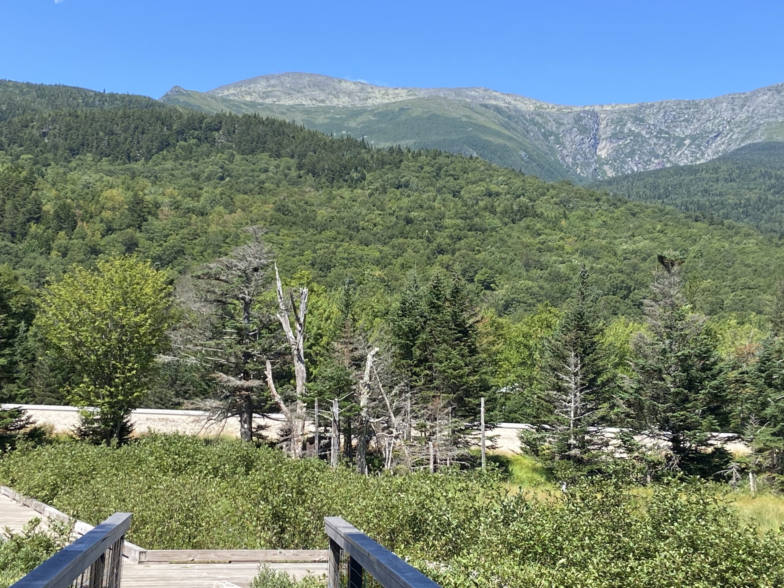


Mt. Washington displaying 4,000 feet plus of vertical relief to Pinkham Notch and its winter attire to Bretton Woods, NH
Mt. Mitchell from Blue Ridge Parkway, NC – Wikipedia Image
In summary, our Mt. W.:
- Ranks number one in “Prominence”;
- Looms bigger and soars higher;
- Features gnarlier hiking routes, with more vertical rise up steeper pitches from almost any distance;
- Has the worst weather on the planet
Verdict: The “preponderance of the evidence” clearly supports Mt. W. as the biggest, baddest mountain of the East. Forget that elevation stat.
Please send comments to newsletternh@amcnh.org
References:
- For a full review of the Kirmse’s and Ferranti’s methods for calculating prominence refer to Kirmse’s hompageand Prominence reference on the Peakbagger.com website. Wikipedia has their usual summary version of history and context of Topographic Prominence.
- Dorfman, Mike. World’s Worst Weather, MWOBS. 2012
- Philip S. Prince, Virginia Tech Active Tectonics and Geomorphology Lab, Searching for the “Biggest” mountain in the Appalachians… and why is “Biggest” in Quotes, 2019
- How dangerous is Mount Washington compared to other peaks in the US? Here’s what the data show. The Boston Globe, May 27, 2024

Mt. Washington in one of his notoriously foul moods